The Cash Flow Bottleneck in Commercial Construction
In commercial construction, cash flow is everything. For General Contractors (GCs) managing massive industrial tilt-ups or commercial retail centers across the Las Vegas Valley, keeping subcontractors paid and materials flowing requires strict adherence to project milestones. However, releasing those funds from a lender or equity partner usually requires an approved AIA (American Institute of Architects) Draw Request.
Historically, securing approval for these bank draws meant waiting for a third-party inspector to walk the site, take ground-level photos on a smartphone, and submit a delayed report. In 2026, top-tier Nevada developers are bypassing this bottleneck by leveraging corporate capture construction photography to provide indisputable visual proof of progress.
What is an AIA Draw Request?
An AIA G702/G703 billing application is the industry standard document used by contractors to request payment for completed work. Because commercial lenders are releasing millions of dollars at a time, they require objective evidence that the work being billed for—such as site grading, foundation pouring, or steel framing—is actually complete.
How Drone Data Accelerates Lender Funding
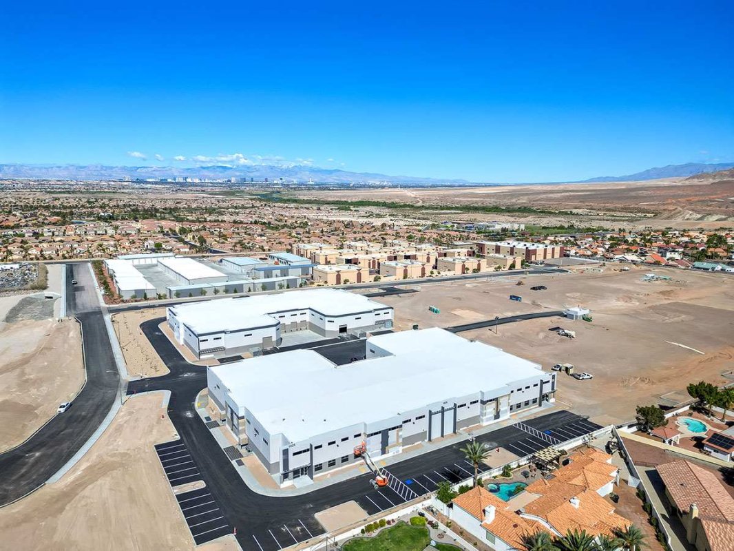
Standard ground photography often fails to capture the true macro-scale of a commercial development. You cannot accurately document a 500,000-square-foot roof membrane installation or a massive concrete slab pour from the dirt.
By scheduling routine FAA-licensed drone flights synchronized with your billing cycle, GCs can provide out-of-state stakeholders and bank inspectors with top-down, high-resolution visual data. When a lender receives an AIA draw request accompanied by perfectly aligned, time-stamped aerial orthomosaics showing exact week-over-week vertical progress, funding is approved with zero friction.
Site Logistics, Safety, and OSHA Compliance
Beyond securing bank draws, regular drone capture serves a critical role in Site Superintendent operations. Navigating heavy machinery, staging laydown yards, and managing subcontractor parking on a tight Las Vegas job site is a logistical puzzle.
High-altitude site mapping allows project managers to evaluate site circulation and enforce OSHA safety compliance from the corporate office. Furthermore, having a permanent, date-stamped visual archive of the entire construction lifecycle serves as an invaluable tool for mitigating liability and resolving subcontractor disputes.
Partnering with a B2B Visual Data Expert
Operating a drone over an active, hard-hat construction site requires a specialized skill set. It requires full commercial liability insurance, FAA Part 107 certification, and strict adherence to LAANC airspace authorizations—especially when building near Harry Reid International Airport or Nellis Air Force Base.
At RCRdigital, we coordinate directly with your Site Superintendent to capture critical milestone data without ever disrupting your crews or heavy machinery.
Stop waiting on slow inspections to get your projects funded. Contact RCRdigital today to schedule milestone-based aerial documentation for your next Nevada commercial development.